User Tools
Site Tools
Table of Contents
GPS Feature
The GPS Signal can be obtained and used via different ways:
- Webinterface
- GPS over IP
- cli status interface
- inside of SDK Skripts
- SNMP
Webinterface
The Webinterface gives you access to the GPS Data. This can be suitable to have a quick look on the current status of a vehicle.
Status Page
Via Status→GNSS you will see this Overview

Interface Page
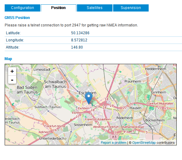
Via Interfaces→GNSS you will see this Map

Data format NMEA-0183
source: http://freenmea.net/docs
NMEA-0183 prefixes (Talker IDs) NMEA protocol can be sent by different equipment. It can be identified by so called Talker Id. Most known one is, of course $GP_ - GPS.
- GA - Galileo
- GL - GLONASS Receiver
- GP - Global Positioning System (GPS)
- GN - Global Navigation Satellite System (GNSS), combined services
GPS over IP
We use version 3.9 of gpsd as a GPS via IP Daemon
We support the following modes:
- on request (clients must send R after connect to get NMEA frames)
- in raw mode (clients are served directly with NMEA frames after connection)
- in super raw mode (clients are served directly with NMEA frames after connection)
- in JSON mode (the new JSON interface is provided to clients after connection)
// get JSON
?WATCH={'enable':true,'json':true}
// get NMEA
?WATCH={'enable':true,'json':false}
?WATCH={'enable':true,'nmea':true}
?WATCH={'enable':true}
For more information on the new JSON interface see http://www.catb.org/gpsd/client-howto.html
Clients
Linux clients are cgps, gpsmon and gpspipe. You can install them via apt-get install gpsd-clients
To see the NMEA Data you can also use any telnet emulator of your choice: putty, hyperterminal etc.
cli status interface
The Command Line Interface can be used via telnet, ssh or serial terminal access.
With the command “cli status gnss” you will seethe current gps data.
To have it in the right format for using inside of scripts (bash, python etc.) you can use the parameter “-s”
SDK Scripts
Within the SDK you can reach the gps data by requesting the status parameter as in the cli example or you can retrieve the data from the gps over IP daemon to distribute it further.
Cli data can be retrieved as follows:
status=nb_status("gnss");
dump(status);
Result:
struct(15): {
  .GNSS1_MODULE_TYPE = string[5]: "me909"
  .GNSS1_MODULE_INFO = string[126]: "Manufacturer: Huawei Technologies Co., Ltd.  Model: ME909u-521  Revision: 11.235.07.00.00  IMEI: 860461024127634  +GCAP: +CGSM"
  .GNSS1_LONGITUDE = string[8]: "8.572821"
  .GNSS1_HDOP = string[4]: "6.00"
  .GNNS1_SYSTEM = string[3]: "GPS"
  .GNSS1_VDOP = string[4]: "0.90"
  .GNSS1_LATITUDE = string[9]: "50.134294"
  .GNNS1_LAST_FIX = string[19]: "2016-05-08 03:42:16"
  .GNSS1_ALTITUDE = string[6]: "146.90"
  .GNSS1_PDOP = string[4]: "6.00"
  .GNSS1_SATELLITES_USED = string[1]: "4"
  .GNSS1_VERTICAL_SPEED = string[5]: "0.000"
  .GNSS1_SATELLITES_INVIEW = string[2]: "12"
  .GNSS1_SIGNAL = string[7]: "present"
  .GNSS1_HORIZONTAL_SPEED = string[5]: "0.000"
}
SNMP
It's possible to poll the postition via SNMP. You will find the entries “gnssLat” latitude and “gnssLon” longitude in the private MIB. Please be aware that the update interval will be 3s.
Example Scripts
- Sending NMEA String on the serial interface: gps2serial
- Forward NMEA String to a UDP Server: gps-udp-client
- Enable/Disable WLAN depending on the current position: gps-monitor
- Creating CSV Logfiles with location data: connection-statistics
